What are borders? Why do we have them? What purpose do they serve? Are they purely artificial, lines drawn on maps by politicians, or do they have counterparts in nature? These are questions we rarely ask, and yet they are important given that borders of all kinds are a ubiquitous feature of our world, a feature we apparently cannot do without. International law might define a border as the line of demarcation separating two contiguous sovereign states or other officially recognized jurisdictions, but this definition loses in substance what it gains in precision. Clearly, borders have meant different things to different people at different times and places. Charles Bungay Fawcett, a little known British geographer whose work spanned the first half of the twentieth century, did address these questions in two overlapping studies—Frontiers and Provinces of England—both of which he wrote as World War I was drawing to a close and the challenges of the peace were becoming clear.
1
In the years leading up to the war, Britain’s political class worried incessantly about borders. Speaking on the topic at Oxford in 1907, Lord Curzon pointed out that the “most important wars” of the previous century had all started as disputes over borders, a situation that would only grow worse in an age of increasing imperial rivalries. Curzon, who had recently served as viceroy of India (1899–1905), was well aware of the British Empire’s vulnerabilities. “In North America,” he informed his audience, “we have a Land Frontier of more than 3,000 miles with the United States. In India we have Frontiers nearly 6,000 miles long with Persia, Russia, Afghanistan, Tibet, China, Siam, and France. In Africa we have Frontiers considerably over 12,000 miles in length with France, Germany, Italy, Portugal, and the Congo State, not to mention our Frontiers with native states and tribes. These Frontiers,” he continued, driving his point home, “have to be settled, demarcated, and then maintained. We commonly speak of Great Britain as the greatest sea-power, forgetting that she is also the greatest land-power in the Universe.”
While Curzon fretted over Britain’s imperial frontiers, others began to question the rationale for their country’s internal boundaries. The Irish home rule crisis, coming to a head in 1914, raised the possibility that the United Kingdom might be reconfigured as a federation of four nations, an arrangement popularly known as “home rule all round.” Federalists argued that providing England, Ireland, Scotland, and Wales with their own national parliaments, while retaining an imperial parliament at Westminster to preside over the whole, would achieve autonomy for Ireland while preserving the union. They also suggested that devolving authority onto four national assemblies would improve government efficiency by redirecting local business from the center to the periphery. British plans for postwar reconstruction also raised the issue of internal boundaries and for similar reasons. The state had assumed so many responsibilities during the war that reformers foresaw a time in the near future when the burden of government would become more than its institutions could handle. They especially worried that international and imperial affairs would take precedence over domestic concerns, causing parliament to bog down and ignore local needs. The sheer complexity of the problems requiring attention—everything from housing, health, and education to labor relations and industrial planning—only made matters worse. As parliamentary business mushroomed, reformers turned to devolution as a way forward, prompting schemes for subdividing England into provinces, each with its own assembly, based on an entirely new set of internal boundaries. Delegating authority to these provincial assemblies, they argued, would relieve central government of its burden, while improving efficiency and returning local initiative to the people.
The onset of World War I placed the question of borders in even starker relief. At the time, British observers often attributed the conflict to the precariousness of borders in those parts of eastern Europe where the rise of nationalism had challenged the status quo. From the Baltic to the Balkans, nationalists were demanding the revision of existing borders within the German, Russian, Austro-Hungarian, and Ottoman empires. On two occasions, their ambitions led to war in the Balkans. Serbia, Bulgaria, Montenegro, and Greece first wrested territory from the Ottomans in 1912–13, and then fought among themselves in 1913 to determine where the new boundaries should fall. World War I also began as a border dispute in the Balkans before spreading to the rest of Europe. The nationalists who assassinated Franz Ferdinand hoped to spark a crisis that would result in the fragmentation of Austria-Hungary and the enlargement of Serbia. Alsace-Lorraine’s problematic inclusion within the German Empire, a constant reminder of France’s defeat in 1870 and a blow to its national pride, fueled French antipathy toward its eastern neighbor. Belgium’s frontiers failed to prevent the German army from invading France, and their collapse in 1914 provided Britain with a justification for entering the war. Dreams of acquiring Trento and Trieste eventually convinced Italy to ally with Britain and France. As the war came to an end, Europeans readily acknowledged that their continent’s political map needed to be redrawn.
But what made for an effective border? A meeting of the British Association for the Advancement of Science, held at Newcastle-on-Tyne in September 1916, set out to answer that question. The speakers, Sir Thomas Holdich and Professor L. W. Lyde, offered fundamentally different answers. Thomas Hungerford Holdich (1843–1929), a retired career officer in the Royal Engineers, had spent three decades in India, surveying the northwest frontier with Afghanistan, demarcating borders, and mapping unknown regions. According to a younger member of the Survey of India, Holdich’s “strict scientific training, his capacity to endure the… heat of baking deserts and the cold of Himalayan heights, his adventurous enjoyment of tight corners, all combined to make him an example to his successors on the frontier.” Regarded as an expert on borders owing to his extensive firsthand experience, he was appointed in 1900 to the Arbitration Tribunal that settled the disputed boundary between Chile and Argentina. His adversary at the Newcastle meeting was the much younger Lionel William Lyde (1863–1947). A humanist educated in the classics, Lyde had come to geography not through formal training, but out of an interest in the physical environment’s impact on ancient history. A writer of popular textbooks, he became in 1903 the first professor of human and economic geography at University College, London. A “brilliant lecturer,” according to one obituarist, he “sought above all to develop what he called the capacity for accurate imagination and gave his students vivid unforgettable impressions of areas which he often knew himself only at second hand.” An amateur in many respects, Lyde showed little interest in fieldwork.
Holdich and Lyde brought two irreconcilable perspectives to the discussion at Newcastle. As it happened, Lyde could not make the meeting on account of illness, so his paper was read for him. Holdich, reflecting the wartime mood and his own experiences in India, argued that political boundaries had one purpose only: to maintain the peace by separating hostile nations. They should respect the principle of nationality and avoid creating minorities, but above all they should present as insurmountable a barrier as possible. This barrier, he insisted, “may be natural or it may be artificial; but in either case it must be made as secure as Nature and Art can make it, as in this imperfect world peace can only be based on security.” Boundaries that followed mountain ranges met this requirement best. Looking to the future, Holdich predicted that Europe’s postwar boundaries would conform to elevated ridges wherever possible, with fortifications filling in the gaps. If Holdich thought about boundaries as obstacles to war, Lyde conceived of them as encouragements to peace. He placed great trust in democracy—“now sufficiently mature”—believing that it had the power to reconcile former enemies. Political boundaries, it followed, should aid this process of reconciliation by fostering contact and communication between nations. “For these reasons a river is much more suitable than a mountain range. It is a feature on and along which men do naturally congregate in peaceful occupations, and where even the most discordant elements can show only a minimum tendency toward discord.” Mountains or rivers, barriers of separation or avenues of communication—here was the stark choice that Holdich and Lyde presented to their wartime audience, as the battle of the Somme wore on.
Lyde had made the case for rivers early in the war, first in a paper delivered before the Royal Geographical Society in December 1914, and then in a short book published the next year. In both works, he laid down three principles: borders and nationality should coincide as much as possible; possession of contested regions should be assigned to those nations most open to assimilating minorities; and the geographical feature used to define borders should be one that encouraged people to interact peacefully. A lasting peace, in other words, must attend to the principle of nationality and it must treat minorities fairly. But most important: “all frontiers, as far as possible, should be identified with geographical features which are associated naturally with the meeting of peoples and persons in the ordinary routine of peaceful intercourse.” Lyde then identified the “navigable river” as the one natural feature that could best establish a border between communities while encouraging friendly interactions. River boundaries had their advantages: they were easily demarcated, they offered protection against adversaries, and they allowed the populations on either bank to communicate peacefully with each other and advance civilization—because, he said, “civilization is essentially progress in the art of living together….” Looking into the future, contemplating a world that was not at war, Lyde foresaw a time when “the principles underlying the delimitation of a frontier will be such as involve all possible aids to the peaceful meeting of nations, not to their parting.”
Holdich strongly disagreed. In his own book on borders, published in 1916, he took Lyde to task. War and civilization, he argued, went hand in hand. As nations progressed, they tended to expand at the expense of their neighbors. Borders, therefore, had to be substantial if war was to be avoided: “Boundaries are the inevitable product of advancing civilisation; they are human inventions not necessarily supported by nature’s dispositions, and as such they are only of solid value so long as they can be made strong enough and secure enough to prevent their violation and infringement.” While Holdich agreed with Lyde that borders should conform to nationality, he doubted that nations would ever overcome their hostility toward one another, and he deemed it foolhardy to think that insecure borders would ever cause them to live together in peace: “I need not again insist that boundaries are not set up in this world of human ambitions and land hunger for the purpose of assimilating the peoples on either side, or of providing them with suitable accommodation for meeting one another.” As for the future, Holdich’s outlook was bleak: “Ages yet will pass in the world’s history before civilisation becomes the basis of international unity. No sooner are human passions aroused, even in nations, than primitive and savage characteristics betray themselves. Then the laws of civilisation are cast to the winds, and forcible separation becomes again the stern law of political boundary making. The Pyrenees stand for an excellent example of what that separation should mean until the advent of the Millennium.”
2
Perhaps the most perceptive contribution to this discussion of postwar boundaries came from Charles Bungay Fawcett (1883–1952), whose Frontiers (1918) must rank as a minor, though largely forgotten, classic in the field. The book began as a lecture delivered first in 1915, and then again in 1916. It was clearly a product of its time, a geographer’s attempt to improve the prospects for peace in wartorn Europe. Fawcett had attended the session on borders at the meeting of the British Association in Newcastle. He had read Lyde’s Some Frontiers of To-Morrow and Holdich’s Political Frontiers and Boundary Making, and he acknowledged having learned from them both. But his book had a different emphasis than theirs.
In the first place, Fawcett concentrated on frontiers, rather than on boundaries. The distinction was important. He began with a commonplace observation: that the density of human population varied tremendously from one location to another. “Even in so small a country as England,” he pointed out, “where every patch of ground has its owner, there are large areas, such as the Pennine moorlands, which are without permanent human inhabitants. In contrast to these empty spaces are the densely crowded urban regions.” He then defined a frontier as the thinly populated stretch of land that surrounded an area of settlement, isolating it from its neighbors. These frontiers thus served as natural borders, or as natural “zones of separation” as he sometimes called them. Examples ranged from the Atlantic Ocean, which formed a permanent frontier between Europe and the Americas, to the far more porous fenland that once separated the early East Anglian kingdom from the rest of England, or the Pripet marshes that stood between eastern Poland and western Russia. These zones of separation were a fact of nature, a regularly occurring feature of the earth’s surface. They affected both plants and animals, and they owed their existence to variations in the earth’s ability to sustain life. Populations tended to thrive wherever conditions were favorable, and to melt away as those conditions became increasingly inhospitable. Fertile river valleys, for example, were usually more thickly settled than barren mountainsides. Because the earth’s surface was so irregular, supporting different kinds of life in different places, it had grown into a patchwork of flourishing communities surrounded by relatively empty frontiers.
Fawcett’s thinking was both naturalistic and developmental. Frontiers, as he presented them, not only occurred in nature, but they had exerted a profound influence on the evolution of all living things. As zones of separation, they had ensured that communities developed in isolation from one another. Among plants and animals, this isolation had contributed to the evolution of distinct species. Among humans, it had encouraged the formation of diverse cultures. As people congregated in those fertile areas that were life supporting, they tended to form “homogenous” groups, adapting to their particular environments and developing cultural and racial traits that set them apart from other groups. “Such differences,” he explained, “might be merely distinctions of dialect and local customs, as between Yorkshiremen and Lancashiremen, or they might extend to complete differences of race, of language, and of culture, as between the peoples of India and of China.” Asked to account for the emergence of nations, and for the differentiation of regions within nations, Fawcett pointed to those variations in the earth’s surface that long ago had given rise to different environments and to frontiers, to those zones of separation that encouraged communities to follow their own paths. Consider Great Britain. As an island, Britain had developed in relative isolation from the continent, the sea acting as a barrier frontier in the past as well as in the present. Within Britain, highland barriers had guaranteed the survival of the Welsh and Gaelic languages along with the Welsh and Scottish nations. Other similar landforms—the East Anglian fens, for example, or the forest of the Weald and Romney marsh, which set Sussex apart from other counties—accounted for regional differences within England itself.
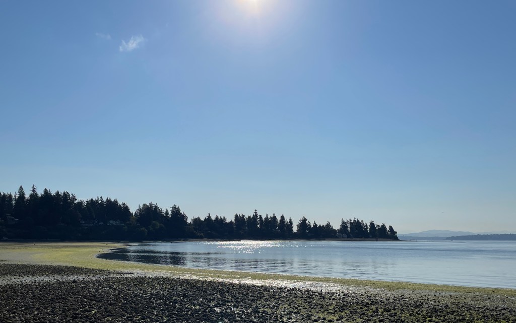
All natural frontiers, Fawcett then pointed out, shared a common characteristic: they possessed width. Even those transitions that seemed to occur abruptly proved, on closer inspection, to involve wide margins, where one physical feature shaded into another. The coastline, for example, despite the terminology, was hardly a line at all, but rather a tidal plain, “a zone of variable, and constantly varying, width,” sometimes land, sometimes water. Nature, he continued, was full of such “fluctuating” frontiers: the snow line on mountains, the scree at the base of cliffs, the foothills separating mountains from the plains below. Whenever frontiers acted as broad zones of separation, they tended to contain elements drawn from all the communities adjacent to them. This intermingling was especially true of the frontiers separating human populations. Consider those linguistic borders that would play such an important role in Europe’s postwar reconstruction. “In the zone of contact of two languages,” he noted, “there is usually a considerable intermixture…. It is not in a frontier province that we expect to find linguistic purity….” French and German coexisted in the Rhineland, Slavic and German on the Polish plain, Spanish and English in the American southwest. What was true for languages was even more true for cultures. Fawcett cleverly presented seaports as extensions of the sea, which acted as a broad frontier separating all maritime nations:
The sea has been in modern times the great highway of the world; and the great seaports show in the mixture of peoples in their cosmopolitan populations that here also is an area of mingling of peoples. The country which borders the open sea is neighbour to all the peoples who go down to the sea in ships; and in the streets of great seaports—of London, Liverpool, New York, Hamburg, Marseilles, and other ports—may be seen representatives of most of the peoples of the earth.
The sharp political boundaries found on maps, it followed, were human contrivances that had no counterpart in nature. We might prefer to divide the land into neat compartments—“since line boundaries are as convenient for thought as are precise definitions in other matters”—but nature worked in other ways.
Frontiers was a beautifully argued book, and yet for all its persuasiveness, readers might legitimately have questioned the extent to which natural frontiers still affected human affairs. The criticism was not lost on Fawcett, who was the first to admit that technological advances had diminished the relevance of frontiers for human populations. Steamships regularly crossed oceans, railways conquered deserts, tunnels passed through mountains. Few natural impediments in the modern age were formidable enough to forestall human interaction. That fenland, for example, which had once isolated East Anglia, forming “an effective zone of separation,” had long since been drained and crisscrossed with roads. And yet, despite all this progress, Fawcett never doubted that the frontier remained a meaningful geographical concept, especially given humanity’s dependency on the physical environment. Even today, we might add, frontiers arising from variations in the earth’s surface are still very much a part of our world. As warming temperatures, desertification, and rising sea levels alter the habitability of land, populations of plants, animals, and humans are migrating in order to survive. They are gathering in new population clusters separated by frontiers made up of land that is no longer fit for life.
Fawcett gave considerable thought to the role frontiers had played in history, and his conclusions combined insights drawn from both Holdich and Lyde. On the most basic level, he argued, frontiers provided defense against armed attack. They separated political communities, defined the extent of their territories, and contributed to the stability that made collective life possible. Frontiers also protected against the spread of contagious disease, regulated the influx of foreigners, and turned away unwanted trade. Fawcett, reflecting the mood of the times, assumed that states were naturally aggressive and that fortified frontiers were necessary for peace. “So long as war remains a probability…,” he predicted gloomily, echoing Holdich, “the need for self-preservation on the part of each state will ensure that this protective function of the frontier shall remain its most important and prominent one.” But Fawcett also foresaw a more peaceful time in the not-so-distant future when war would no longer define the relations between the advanced nations of the world. Given that no modern state could ever remain self-sufficient, frontiers had to operate not only as defensive barriers, but also as places of “intercourse with the foreigner.” These peaceful interactions tended to occur at major seaports, over mountain passes, and wherever roads, rivers, or railways crossed international boundaries, and they could not help but grow more intense in the densely populated heartlands of the European continent. Frontiers serving as a “zones of intercourse,” he continued, now reflecting Lyde’s optimism, were “both absolutely and relatively more important to-day than at any time in the past.
Fawcett had started thinking about international frontiers during the early years of the war and had published his book in 1918 as hostilities were drawing to a close. It was clearly a tract for the times, and he ended it, appropriately enough, with a chapter pointing toward the peace settlement. He noted at the outset that modern statesmen tended to prefer precise political boundaries, and he accepted such precision as a prerequisite for peace. He also endorsed the widely held belief that political boundaries should follow as closely as possible the contours of language and nationality. He pointed out that nationalism was a modern phenomenon, dating back no further than the nineteenth century, and that the friction between emerging nations and older empires, especially in central and eastern Europe, had been the cause of most recent conflicts, an obvious reference to the Balkan and world wars. But respecting the rights of nationality with simple and precise boundaries was no easy matter as any glance at a map of Europe’s linguistic complexity would make abundantly clear: “In all the lands of East Central Europe,” he explained, “from the Baltic to the Aegean and the Black Sea to the Adriatic, the dominant fact of national distributions is that of intermixture. Hardly anywhere in this part of the Continent is there a large continuous area inhabited solely by people of one nation. Nowhere are the territories occupied by the different nations marked off from each other by clearly defined limits for any considerable distance. Every nation here includes within the area it claims enclaves inhabited by foreigners, and has itself detached islands of its people in foreign territory.”
Fawcett’s solution to this problem was to place national boundaries as deliberately as possible. They should minimize the incidence of minorities, encouraging either the assimilation or relocation of those minorities whose presence could not be avoided, and they should make use wherever possible of “natural zones of separation,” of frontiers in other words. This last consideration was crucial. Adhering to it would not necessarily produce perfect boundaries—there would always be problems—but it would result in the best boundaries possible: “the frontier of separation,” he urged, “where the boundary line is drawn along a natural barrier in a thinly peopled area, so obviously minimizes the chances of friction and the temptations to aggression, and so makes for the greater stability of the state….” Europe’s geography had determined the location of its nationalities, with regions of dense population surrounded by sparsely populated frontier zones of mixed ethnicity. These frontiers had emerged over the course of centuries, corresponding to the contours and quality of the land, providing nations with the means to defend themselves as well as opportunities for peaceful interaction with their neighbors. To ignore such frontiers would mean ignoring the lessons of the historical process that had given rise to Europe’s national diversity in the first place.
In answer to Lyde, Fawcett pointed out that rivers by themselves rarely formed frontiers. Because populations tended to migrate along waterways and settle on both banks, rivers ran through nationalities rather than dividing them. Consider the number of European cities that sit astride great rivers: London (Thames), Paris (Seine), Rome (Tiber), Vienna and Budapest (Danube) come readily to mind. “There are,” he explained, “very great disadvantages associated with the adoption of rivers as boundaries between civilized states. A valley is a natural unit; and as the land becomes fully occupied the river tends to become the axial line of an area of dense population, and so a place of frequent intercourse in trade and social life: so that the peoples of its banks become more or less assimilated to one another. Very few rivers form linguistic or cultural divides….” Holdich stood on firmer ground since mountain ranges often gave rise to frontiers of separation: the Alps and Pyrenees, for example, set France apart from its neighbors. But Fawcett warned that frontier zones rarely followed the crests of mountain ranges, but tended to fall at the meeting point of their highland and lowland cultures. When contemplating Europe’s postwar boundaries, it followed, peacemakers should avoid thinking in terms of rivers and mountains, and focus instead on frontiers of separation wherever they might fall. Fawcett never located these frontiers on the map, but he was sure they existed: “The fact that Europe possesses many such frontiers of separation, sufficiently strong to give moderate security but not so difficult as to prevent human intercourse, has been a very important factor in the development of that diversity of regional cultures in a unity of European civilization which has placed its peoples in the forefront of human progress.”
Fawcett’s disagreement with Holdich and Lyde went deeper, however, than just rivers and mountains. One anonymous reviewer of Frontiers noted Fawcett’s “philosophical outlook” and his “interest in the relations of geography and history.” Fawcett’s argument with Holdich and Lyde was philosophical, rooted in his profound sense that geographical factors provided some of the most powerful determinants of history. “Every human group,” he once observed, was “dependent” on the earth, and to write their histories without paying close attention to geography would be impossible. For Fawcett, geography presupposed geology, the most historical of sciences, a discipline that attempted to understand the development of the earth’s surface, to understand how things had become what they were. Applied to borders, this preoccupation with development led to a historical approach: borders, in the form of frontiers, existed in nature and had shaped the course of human development, bringing distinct communities into being, preserving their independence, and enabling them to interact constructively with one another. Neither Holdich nor Lyde shared this appreciation of historical processes. Their ideas about how best to maintain the peace may have been polar opposites, but their application of geography was similar: boundaries should put natural features, mountains or rivers, to work serving human ends. Fawcett’s emphasis was different: boundaries should pay close attention to history to see how geography had shaped the human world and then follow its design as best they can.
3
Fawcett, who once described himself as a “Northcountryman,” was a regionalist first and foremost. He was born and raised at Staindrop, in County Durham, attending school there and at Gainford in the Tees Valley. He earned a BSc from University College, Nottingham, in 1908, and subsequently taught at Long Eaton County Secondary School in Derbyshire. His earliest publications all dealt with local geography, suggesting that he first thought about borders not on the international, but on the regional level. Consider his study of Long Eaton, a “small manufacturing town” that had recently felt the encroachments of industrialization from neighboring Nottingham and Derby. He knew the place well, having worked there as a teacher before the war. He began his study by describing the area’s physical geography, identifying the natural processes that had shaped its current landscape. He then turned to human geography and the development of the region’s transportation network. Finally, he considered the placement of parish and county boundaries. His conclusion: these boundaries made little sense after the onset of industrialization. “Here, as elsewhere in Britain,” he wrote, “the local boundaries were drawn several centuries ago in accordance with the needs of the strongly localized agricultural life of the time. And here, as over the rest of industrial Britain, these ancient borders are a cramping misfit for the growing and spreading industrial and commercial urban regions, and also for the no longer isolated agricultural centres.” Fawcett then assessed the consequences of this “cramping misfit,” pointing out that the old administrative boundaries interfered with railway development, the extension of sewerage systems and electrical grids, the provision of public health and poor relief. As a matter of “practical reform,” he added, they should be brought into alignment with “the redistribution of population and the changed conditions of modern life.”
Fawcett was also an early enthusiast for federalism and devolution. The call for Irish Home Rule before the war, along with the growth of Welsh and Scottish nationalism, had encouraged him to start thinking about what a federal Britain might look like. Fears that Parliament was too busy with national and international affairs to pay much attention to local needs also pushed him to endorse devolution. He clearly had kept abreast of the debates over home rule and imperial federation that had preoccupied politicians before and during the war. Considerations such as these convinced him that dividing England into a number of provinces would benefit everyone. These new English provinces, he argued, should be “comparable in resources and population” to Scotland, Ireland, and Wales, guaranteeing that no one region would outweigh the others, and they should all enjoy an equal degree of self-government should they choose to accept it. Finally, these divisions should not be imposed abstractly, as had occurred in France after the Revolution, but should emerge organically out of England’s physical geography. Fawcett’s wartime employment with the Ordinance Survey in Southampton—poor eyesight had exempted him from serving in the trenches—provided access to maps and other sources of geographical information enabling him to draw up a proposal. He presented his initial findings to a meeting of the Royal Geographical Society in 1916, and then published their final version right after the war as The Provinces of England.
Fawcett’s plan called for dividing England into twelve provinces, each of which would meet certain basic criteria. Each would have a centrally located capital capable of providing a focus for provincial life; each would be large enough to warrant self-government, but not so large as to dominate the others; and each would appeal to the “local patriotism” of its inhabitants. But most important, each province would “be so chosen as to interfere as little as possible with the ordinary movements and activities of the people.” This final condition meant paying close attention to geography. In determining the placement of boundaries, Fawcett followed as best he could the procedure he had outlined in Frontiers. He identified areas of dense population and then placed his boundaries in the thinly settled frontiers that separated them from one another. “From this principle,” he explained, “it follows that the boundaries should be so drawn that any area of continuous dense population should be kept as a whole in one province: and hence that the boundaries will in general be drawn along those more thinly peopled tracts of the country which do in fact form, relatively, areas of separation between the more populous districts.” Because the general movement of England’s population over the millennia had been from open uplands to forested river valleys, these areas of dense population tended to be found along rivers. “A valley,” he continued, “is a natural unit area for most purposes of human organization, primarily because the higher ground which separates one valley from another is, to a greater or less extent, an obstacle to intercourse and less favourable to settlement and occupation. Our population is mainly in the valleys. From this it follows that the boundaries should be drawn near the watersheds.”
Fawcett’s proposed Province of North England provides an excellent example of how this procedure worked. Given that it incorporated some or all of five existing counties—Durham, Northumberland, Cumberland, Westmorland, and Yorkshire—it represented a significant revision of existing boundaries. It encompassed two areas of dense population—the Durham-Northumberland coalfield in the east, and the Cumberland coal and iron field in the west—and even though a natural frontier separated these two areas, Fawcett chose to combine them in one province because the population of the second area was too small to warrant self-government. The new provincial boundary, which he drew with considerable precision, generally followed watersheds and avoided cutting valleys in two. Newcastle served as the provincial capital, commanding a closely knit population of more than two million and sitting at an important crossroads. Fawcett was pleased with the result and presented it as a considerable improvement on the existing arrangement. The province represented an economic whole, and it possessed a historic unity that fostered a deep sense of local patriotism. “The area included in the province,” he wrote, “is historically the area controlled by the Lords of the Marches and the Prince Bishop of Durham; and life in it was dominated for centuries by the border warfare with Scotland. That period greatly strengthened the marked unity and individuality of the North Country, a character which is strongly impressed on its regional traditions and folklore.” Poor for much of its existence, the North Country’s coal and iron reserves gave it a centrality during the Industrial Revolution that contributed to its local distinctness and pride: “The steam locomotive and the railway originated here, and so many other of the early mechanical inventions that Tyneside may well be termed the ‘Florence of the Industrial Renascence’…. The North Country traditions of independence and initiative have been carried on to our own days, and well support its claim to provincial self-government.”
What do we learn about borders from Fawcett’s discussion of frontiers and from his work delimiting provincial boundaries? First, we learn that our world is filled with borders in part because they are a naturally occurring phenomenon. We encounter borders everywhere we look and they are responsible for much of the variety that makes our world interesting. Anyone who circumnavigates an island notices the border dividing the ocean and the land, as well as the tidal plain serving as a frontier between them. Anyone who observes a mountain range over a period of time notices the seasonal rise and fall of the snow line, marking out a zone of separation between the icebound peaks and the more temperate lower elevations. Anyone who drives across a prairie notices the abrupt shift from the arid upland to the rich vegetation of a river valley. Fawcett draws our attention to these features of the land, pointing out how they reflect those variations in the earth’s surface that have contributed, over immense periods of time, to the evolution of the world’s flora and fauna as well as to the diversity of our cultural communities. Advances in technology may have diminished the power of these frontiers to keep us apart, but their imprint is still there for those who care to look for it.
We also learn that borders are tools we use to ensure that our collective life runs smoothly. Well placed international boundaries provide a necessary means for maintaining peace, while domestic boundaries lay the groundwork for administrative efficiency. Fawcett was quite adamant regarding this second point, insisting that internal political divisions, and the boundaries that define them, “exist only in order to facilitate good government.” Borders serve our communities by imposing order on the world, marking out zones of competence, so we can manage our affairs. Local boards of health or education, public utilities such as water or electricity, transportation authorities only operate effectively if they have clearly defined areas of jurisdiction. Finally, borders are crucial for a healthy democracy. Fawcett believed that thriving regional or local communities, free from outside interference, provide the lifeblood of democratic societies. Nations that recognize “the existence of many diverse regionalisms” and that encourage “the fullest and freest development of regional individualities,” he was convinced, would be stronger than nations laboring under “a mechanical national uniformity.” Centralization only destroys local initiative, saps the energy of the periphery, and winds up enfeebling the whole. Well placed domestic borders, it follows, not only ensure that regions function smoothly, but they also keep the central authority at bay, guaranteeing that local business will be handled locally.
Finally, Fawcett teaches us that borders work best when they conform to nature. He was certain that nations, regions, and towns all have natural boundaries that we should respect when deciding where to locate their divisions. Borders should not be judged by whether or not they meet the needs of a central authority or satisfy some abstract notion of uniformity. The best borders—and here is the thought he leaves us with—combine artifice and nature, providing communities with good governance while adhering as closely as possible to the frontiers that have shaped them. In the aftermath of the war, with the need to lay the groundwork for a lasting peace foremost in people’s minds, abstract borders had an irresistible appeal. Strong, clearly visible, straight lines would create a tidy, peaceful world by imposing order. Fawcett, however, chose to establish a different kind of order, not an abstract order, but a natural order sensitive to place. A boundary, he believed, should reflect the world it is intended to serve. A natural boundary does not discipline the inhabitants within it, but enables them to go about their daily business with the greatest possible ease. For Fawcett, the lines on the map should reflect the world, the order coming from within, not from without.
4
Fawcett’s Frontiers and Provinces of England can be read as tracts for their times. Both books emerged out of the preoccupation with borders—regional, national, and imperial—that vexed English statesmen like Lord Curzon in the years leading up to World War I. Frontiers was a geographer’s contribution to the peace settlement, a corrective to the rather simplistic arguments exemplified by Holdich or Lyde. Provinces spoke to the debates over devolution that grew increasingly insistent as the immensity of postwar reconstruction became clear. But Fawcett’s thinking about borders also reflected deeper cultural currents, especially the fixation on rural England that surfaced well before the war and became prominent in the interwar period.
Looking back from 1940, George Orwell identified an enthusiasm for country life as one of the principal characteristics of English culture in the early 1920s. This ruralism often came across as an evocation of the countryside in art and music, poetry and prose. But it also appeared as an appreciation of the land itself. When asked in 1917 why he was enlisting, the poet Edward Thomas supposedly picked up a handful of English soil and said, “Literally, for this.” Whether the story is apocryphal hardly matters. Its suggestion that England’s essence was, in some mystical way, present in its very soil has made it irresistible to generations accustomed to celebrating their rural heritage. Geography, Fawcett’s chosen profession, was also closely bound up with the land, with the study of geology and the forces shaping the earth’s surface. In a paper on “The Middle Tees and its Tributaries,” read before the Royal Geographical Society in 1916, Fawcett got no further than the rivers, prompting one listener to complain that the paper was so focused on the land’s form that it neglected to mention its inhabitants. Fawcett strongly urged geography teachers—and he was one—to take their students outside so they could look at the land around them and see how it had shaped their lives, and he made excursions into the countryside a regular part of the vacation courses he taught for school teachers. Fawcett’s love of the land never entailed a rejection of industrialization or cities—Long Eaton, after all, was a manufacturing town, and his proposed province of North England centered on its coal and iron fields—but he shared with ruralists an appreciation for communities rooted in the landscape.
Fawcett’s regionalism also reflected these deeper cultural currents. A tendency to view England as a collection of discrete places, rather than as a national whole, characterized the period’s fascination with the countryside. As Orwell put it, speaking of the vogue for Housman: “the nostalgia of place names” went hand in hand with “thatched roofs” and the “jingle of smithies.” In one of his last essays, written just before he died in 1917 in the battle of Arras, Edward Thomas asked, what is England? His answer: an agglomeration of places. England, he said, had always been a country “of innumerable holes and corners, and most men loved—or, at any rate, could not do without—some one or two of these….” Sometimes these places were quite small. In his most anthologized poem, Thomas celebrated the isolated village of Adlestrop, a mere stop on the railway from Oxford to Worcester. Sometimes they were as large as regions. Thomas Hardy, possibly the period’s most popular writer, had mapped out Wessex in his novels and poems, while Hilaire Belloc invented the South Country, which almost single-handedly defined the ideal of rural England for generations to come. Other writers and artists were similarly associated with specific regions, none more so than the illustrator Donald Maxwell, who turned out a series of guides to England’s counties, beginning with Unknown Kent in 1921 and extending to half a dozen more southern and eastern counties before the end of the decade. Maxwell traveled haphazardly, describing where he had been in considerable topographical detail, sketching what he had seen, and telling stories about it. His purpose, he said, was to introduce his reader to “places not easily found, and show them to him in such an atmosphere that he will see the things that are hidden.” Maxwell rarely spoke of England as a whole, but concentrated instead on the specific places he was exploring. If his England was an “imagined community” in the sense that Benedict Anderson has made famous, then Maxwell “imagined” it as a loosely knit assemblage of localities rather than as a consolidated nation.
For England’s political class, this ruralism entailed more than mere nostalgia for a pre-industrial past. Behind its fascination with thatched cottages and blacksmiths lurked a genuine concern with the health of the English countryside and the ability of English agriculture to meet the nation’s needs. Was the land producing as much food as it could? Was it providing rural workers with the best livelihood possible? The facts were plain, the Times reported in 1913: “What catches the ear is the cry that rural life is declining… in both respects.” England had long been dependent on imported food and was now paying the price for its negligence. An influx of cheap foreign grain after 1874 had undercut the English farmer, depressing wages and driving labour from the land. English agriculture, the Times concluded, was “a sick industry. With the onset of war in 1914, the illness turned critical. The need to protect shipping lanes for importing food distracted the Royal Navy from offensive operations. Shortages, especially after 1915, called for rationing, price controls, and subsidies to farmers in an effort to keep prices at affordable levels and forestall starvation. The poor physical fitness of English soldiers raised doubts about the ability of the countryside to provide healthy new recruits. As the war came to an end, plans for reconstruction routinely called for a regeneration of rural life, now interpreted broadly to include colliery and mill villages, market towns, shopping centers, and other places with non-agricultural populations. Industrialization and urbanization, people feared, had gone too far, encroaching on the land and sapping the nation of its vitality. Faced with another great calamity, they wondered, would English agriculture be able to feed the nation and supply it with a fighting force?
Worries like these prompted Fawcett, along with other like minded academics, to turn their attention to the countryside and its problems. Patrick Geddes, a Scottish thinker with broad, multi-disciplinary interests, showed them a way forward. Geddes (1854–1932) had studied under Darwin’s colleague Thomas Henry Huxley in the 1870s, and then taught biology at University College Dundee from 1888 to 1919. But if he began his career as a scientist, he established his reputation as a sociologist who brought the evolutionary approach he had learned from Huxley to the study of human society. What particularly attracted geographers to Geddes was his call for regional surveys that would focus on the relationship between society and the natural environment. In Geddes’s thinking, regionalism took on a methodological precision. Investigators, he suggested, should begin with a geographical region—a river basin, for example, or a ridge line forming a watershed—and then study how that particular environment had shaped the development of the communities settled within it. These surveys would adopt a historical approach, and when gathered together would present an environmental alternative to the political narratives found in most conventional histories. They would also identify the causes of present-day problems and suggest remedies, for Geddes was convinced that communities prospered when they functioned in harmony with their natural surroundings. As a contribution to postwar reconstruction, he accordingly proposed that regional surveys be prepared for all Britain, and he helped organize a Regional Association in order to promote the project.
Fawcett was also very much involved in the movement. He assisted in the vacation schools organized to inform teachers about regional surveys, he published his Provinces of England in Geddes’s “Making of the Future” series, and he undertook some surveys of his own. Like other geographers, he was concerned with the health of rural England and used his work to suggest ways of improving it. His study of Long Eaton, for example, had proposed relocating municipal boundaries in order to provide a rapidly growing district with more efficient services. His survey of Edale, a remote river valley in Derbyshire’s High Peak District, focused on a rural region that had never prospered until recently, when its fortunes began to improve. Fawcett believed its story had lessons to teach, as did the editors of the Scottish Geographical Magazine, who published the study in 1917 despite its English subject matter. Edale’s problem, Fawcett suggested, had been its chronic isolation. Almost completely surrounded by high moorland, the valley’s inhabitants had no option but to rely on themselves, extracting from the earth everything they needed, often with meager results. But in 1894, this isolation came to an end. The opening of a railway between Manchester and Sheffield, which just happened to pass under the moors and through the valley, connected the region to the rest of Britain. These new conditions, which brought urban markets and populations within easy reach, enabled Edale’s farmers to make more efficient use of their land. Fawcett ended his survey optimistically, pointing to a bright future: “All the valleys of the High Peak District have become holiday resorts in the last few years…. There is little doubt that a similar development, the beginnings of which are already visible, would take place in Edale if its service of passenger trains to the cities on each side of it made this possible.”
Fawcett ended his study of Edale with an apology. He had spent so much time on a region of such “small importance,” he explained, because he was convinced that its evolution and future prospects had lessons for other highland valleys. This solicitude for the countryside characterized much of his early work as a geographer. The lectures he gave and the studies he published during and immediately after the war spoke to the rural revival, and the same could be said for his thinking about borders, especially since a fascination with “bounds” was another facet of the return to the land and could be added to Orwell’s list, alongside place names, thatched roofs, and smithies. While Fawcett was tracing watersheds, amateur antiquaries were exploring the countryside with old charters and Ordnance Survey maps, hoping to discover the location of England’s ancient boundaries, and local vicars were showing renewed interest in the traditional practice of beating the parish bounds. Fawcett’s thinking about borders also reflected a particular moment in the development of British geography as an academic discipline, a moment when its focus was shifting from a Victorian emphasis on mapping uncharted territories to a twentieth-century concern with the influence of the natural environment on human activity. Understanding the emergence of boundaries and determining whether their placement still made sense became one of the geographer’s principal tasks.
We can look at borders from a number of different angles. We can study them as they partition the globe and appear on maps. We can discuss the policies that establish who is allowed to cross them, and evaluate the mechanisms put in place to enforce those policies. Today, discussion tends to focus on policy and enforcement because we are concerned with problems of migration. Fawcett, however, chose a different angle. He was interested in borders as an attribute of the land. No doubt, the cultural moment in which he worked shaped his thinking and limits the applicability his ideas to the part of the world he knew best. But that cultural context also enabled him to see what others might miss. Reading Fawcett today leaves us with an appreciation of borders as a feature of the landscape, like woodlands and fields, roads and footpaths, stonewalls and hedgerows. As he suggested in Frontiers, borders are both a part of nature and a part of the human response to nature. The natural ridge line becomes the division between two human communities; impassable fenland separates two ancient kingdoms. The oldest boundaries have been around for as long as anyone can remember, barely distinguishable from the landforms that determined their placement, directing the flow of people’s lives, until their usefulness comes to an end and their location is all but forgotten, supplanted by more suitable divisions. The meaning of these boundaries persists in the collective memory of the people whose lives they have affected, a part of their heritage, to be valued or rejected, contested like any other relic of the past.
© Timothy Lang | Bainbridge Island, Washington
A footnoted version of this essay can be downloaded here: What Are Borders?
Picture credit: Hawley Cove, Bainbridge Island, Washington. Author’s photograph. The British geographer C. B. Fawcett argued that all natural borders possess width: “The frontier between sea and land, which is so often spoken and thought of as the coast-line, is really a zone of variable, and constantly varying, width. All round our shores the strip between the high- and low-tide marks, the foreshore, is neither sea nor dry land, but alternately sea and land.” (Frontiers, 17)
